
The Jersey digital map enables all interested parties, in both public and private sectors, to access geographical information in a versatile visual environment. The Jersey Mapping is provided in the form of a comprehensive set of GIS data ‘Layers’ combined to provide “off the shelf” business solutions, or to meet your individual requirements better, a more bespoke product can be developed to include consultancy, software, training and support Digimap (Jersey) Ltd also offers a Hardcopy mapping and Aerial Photography service (up to A1 size) to the public, from its office at 69 Halkett Place, St. Helier. Digimap are also pleased to be working with the Government of Jersey on the Differential GPS service, which benefits local Architects, Surveyors, Utility companies and Government Departments. To help us ensure that the mapping data is as accurate as possible, if you notice any omissions or data that you feel is incorrect please report it to: The Mapping Service Team: mst@gov.je
Mapping Data via Digimap.
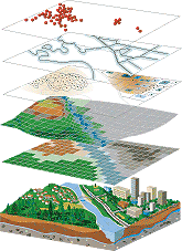
 The Jersey Mapping is provided in the form of a comprehensive set of GIS ‘Layers’ combined to provide off the shelf business solutions, or to better meet your individual requirements, a more bespoke product can be developed to include consultancy, software and training & support The Government of Jersey maintain the Jersey Digital mapping data and hold the sole ownership and copyrights. The Digital data comprises of various data sets: The GIS mapping data is available as a seamless data coverage of Jersey with a comprehensive range of layers depicting the feature types.
- Land Parcels: polygons depicting the inferred extents of individual land parcels. The data is fully attributed with unique identifiers, address details and other geometric data.
- Roads: polygons depicting the extents of the Islands roads with unique and the official road name.
- Buildings: Island building polygons, fully attributed and classified by type.
- Parishes: High Water polygon data set of the Island Parishes and Vingtaines.
- Contours: 5m contours for the Islands.
- Coastal Classification: Polygon layer detailing the coastline from high to low water. The layer is fully attributed to depict areas of sand, rock, cliff and pebbles etc.
- Streams and Water Features: including culverts, ponds and quarries).
The core data sets are compatible with most modern GIS software packages.

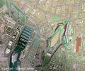
Ortho-photographs: This fully Orthorectified image dataset of Jersey are supplied at a ground resolution of 10cm. Derived from hundreds of aerial photographs, this data set provides a seamless and accurate full colour photographic overlay to the core mapping data sets. Aerial photography was taken on the following dates.
- 21st July 1997
- 16th/17th April 2003
- 10th June 2006
- 1st August 2007
- 23rd July 2008
- 8th September 2009 *
- 21st September 2010 *
- 1st September 2011
- 18th/20th August 2012 *
- 23rd/24th September 2013 *
- 1st September 2014
- 30th July 2015 *
- 16th August 2016*
- 27th August 2017
- 27th September 2018
- 3rd August 2019
- 22nd July 2020
- 1st July 2021
- 22nd July 2022
- 3rd September 2023
* No high resolution Orthophotos were produced from these images.
Historic Maps:
Geo-referenced paper maps: 1795, 1935, 1942, 1958, 1965, 1976, 1981.
CAD Format data: The Island of Jersey is available in a tiled format compatible with most modern CAD software packages. Each tile contains comprehensive data for the entire core mapping data sets, such as Land Parcels, Roads and Buildings etc.
DXF/DWG Tile reference website
Gazetteer: An up to date official Address Gazetteer derived from the Government of Jersey Land and Property Index (JLPI). The powerful data set utilizes the unique identifiers attributed in the core mapping data to link the JLPI to the digital map; this allows powerful searches and analysis to be performed from within the GIS.